Cue the summer of 1874, when the Dominion of Canada was seven years old and the Province of Manitoba only four, when Louis Riel himself was the Member of Parliament for Provencher, and when the population of Winnipeg was almost exactly the same as Niverville’s today (5,000). Niverville was nothing but a proposed stop on the new Canadian Pacific Railway, and the only so-called development there consisted of a couple of storehouses and stables which have all been lost to the sands—or, in Niverville’s case, swamps—of time.
In 1869, the fledgling government of Canada began surveying territory in Rupert’s Land in anticipation of securing it as a province. There was some urgency to complete the process and expand west, as the United States was also in expansion mode and could have competed for the same land. This was a bloody, explosive chapter in Canada’s history during which government surveyors and settlers tangled with the Metis peoples who already lived on the land. Indeed, Niverville and all of southeast Manitoba lie on Treaty 1 territory, the first land treaty negotiated by the federal government with the indigenous people. Treaty 1 was enacted in 1871.
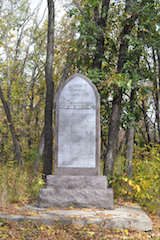
From 1874 to 1876, a large group of Russian Mennonites began their migration here—specifically, to the area known as the East Reserve, eight townships (approximately 750 square kilometres) set aside for the Mennonites by the new province of Manitoba. They arrived first in Halifax, proceeded up the St. Lawrence River, crossed the Great Lakes to Duluth, Minnesota, and took the rail line there to Moorhead (Fargo). From Moorhead, a riverboat transported them north up the Red River, where they landed just seven kilometers southeast of Niverville at the confluence of the Red and Rat Rivers.
But the story of Niverville is greater than the settlement of the Mennonites. From its beginning, Niverville was a somewhat more cosmopolitan town than many of the neighbouring Mennonites communities to the south and east.
In the early 1870s, an Englishman named Joseph Whitehead was commissioned to establish the Pembina Branch of the Canadian Pacific Railway, which was to run from St. Boniface to Emerson bordering the newly minted East Reserve. Whitehead had erected the storehouses and stables mentioned earlier on the west half of Section 30–7–4E, and he chose this land for a rail station. The location was significant in that it also intersected the historic Crow Wing Trail, which brought traffic north from St. Paul, Minnesota.
Whitehead wanted to purchase and develop this quarter in the summer of 1874. However, he was informed by Lieutenant Colonel John Stoughton Dennis, the man hired by the federal Minister of Public Works to survey Canada’s newest province, that Section 30 was part of the Mennonite reserve. Therefore, Whitehead took his request to Jacob Shantz, who was in the process of coordinating the Mennonite settlement. In a letter dated December 31, 1874, Shantz agreed that Section 30–7–4E was ideally suited for a rail station—and indeed, for its own town.
Despite choosing the station site, Whitehead never did purchase and develop the land. The railway, however, finally proceeded, with the first passengers riding south in 1878. It must not have been the smoothest ride, as author Pierre Berton, in his book The National Dream—The Last Spike, was led to call it “the most cursed length of track on the continent” (Toronto, ON: McClelland and Stewart, 1974, p. 147).
Officials for the Canadian Pacific Railway proposed to christen the Section 30 station Niverville, after Chevalier Joseph-Claude Boucher de Niverville, a French-Canadian military officer who during the 1700s had passed through southern Manitoba for a route to the western sea.
The Historical Atlas of the East Reserve (Manitoba Mennonite Historical Society, 2015, p. 99), edited by Ernest N. Braun and Glen R. Klassen, makes a keen observation about the selection of the name: “That Niverville was to be a service centre for a pacifist Mennonite Reserve is an irony probably lost on the CPR official who proposed the name. Since Joseph Whitehead had far more to do with the site selection than anybody else, his name might also have been entirely appropriate.”
Thus enters William Hespeler, a German-Canadian businessman who is the namesake of many local landmarks, such as Niverville’s Hespeler Park. Indeed, the future town of Niverville was briefly called Hespeler before the name Niverville won out. Hespeler was instrumental as an immigration agent, arranging the settlement here of thousands of Mennonites from Russia (modern-day Ukraine).
Hespeler bought 30 acres of the same land Whitehead had been interested in and surveyed it into lots. He then commissioned a town plan and completed several key construction projects in 1879, including that of a hotel, a livery stable, and a grain elevator. This grain elevator was the first to be built in Western Canada and eventually turned Niverville into a significant service centre for the East Reserve.
However, the topography initially worked against Niverville’s usefulness as an entry to the East Reserve, surrounded as it was by impassable swamps. For this reason, Niverville also became home to a host of non-Mennonite immigrants. Its proximity to the new railway brought English-speaking pioneers from Ontario and settlers from Eastern Europe. Thus in a town that today features more than its fair share of Hieberts, Friesens, and Loeppkys, one also finds Churches, Grants, and Stotts.
Over the years, the proposed town site didn’t quite develop according to Hespeler’s original plan. He had intended for Niverville to grow predominantly north of present-day Main Street, but instead it has expanded in the opposite direction. Hespeler and William Pearce, whom Hespeler hired to draw the plan, named the town’s streets after members of their families: Stephanie, Barbara, George, Mary, Ludwig, Georgina, and Alfred. The town’s only avenue, Boscary Avenue, was likely named for Hespeler’s deceased brother-in-law, Charles Boscary de Villeplaine, who had passed away in Paris twenty years earlier.
Until 1984 most streets still officially bore these names. A bylaw was enacted on February 7 to adopt the numbered streets and avenues we use today. Kaiser Street became Main Street, Eberstein Street became Fifth Avenue, and William Street became Second Street North.
Today, Niverville is more vibrant and cosmopolitan than ever, with the recent influx of new residents to our sprawling subdivisions. To those long-time Nivervillers who may express the occasional worry about our accelerated rate of growth, history clearly shows that change, flexibility, and modernization have always been key ingredients in our social fabric. Since its inception, Niverville has been a community where people of all stripes come together. So while the times may change, the things that make us great certainly have not.


