

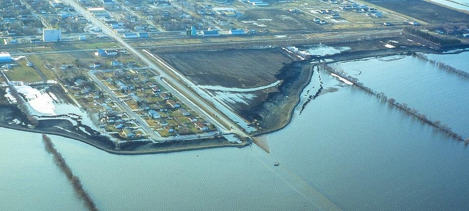
The RM of Ritchot faces a major risk of spring flooding according to Manitoba’s spring flood forecast, released on February 18. Water levels are expected to remain below community dikes and flood protection measures, but the Hydrologic Forecast Centre is predicting a high volume of water passing through waterways in southern Manitoba, including the Red, Rat, and Roseau rivers.
Ritchot has a large amount of low-lying farmland. The flooding situation is carefully monitored each spring and area officials are always on the lookout for trouble spots, such as low roads or highways.
“It’s hard to say what an average spring melt truly means,” says Mitch Duval, CAO for Ritchot. “For the past eight years, it has been fairly ‘quiet’ as far as flooding. The common trouble spots are on lower level road crossings such as Prefontaine Road, Crown Valley Road, the La Salle Bridge at Waverly, Courchaine Road, and Alarie Road… We will likely see a closure of the St. Adolphe north dike and the ‘Richardson Curve’ on Highway 200 will likely be underwater.”
Although Duval has reviewed the latest forecast, he feels it is still too soon to make many plans for the RM’s flood response.
Given the rapid growth of the community, many residents new to Ritchot may not have seen flooding before, whether overland or rising river levels. Flood hazards in any year include thin ice, overland water, culvert blockages, and improper sump pump drainage.
“It has been a while since a significant event,” says Duval. “It’s a good time to remind people to stay away from thin ice, open water areas, and not to travel down a closed road due to flooding.”
He also encourages people to assist by not getting in the way where flooding is happening, to make room for construction equipment to do their thing, and preparing to evacuate if necessary by having a plan in place.
The RM also says that as the melt begins, their team has routine procedures in place to help with drainage.
“Normal spring operations include thawing out frozen culverts, clearing snow in some ditches to help with drainage and water flows, ensuring pumps are ready if needed, doing an inventory check of sandbags, and looking at opening the Emergency Operating Centre (EOC) if needed,” says Duval.
Should water levels rise to a level of concern, the RM has procedures that are ready to be enacted should residents need help. In March, a provincial seminar and further update will take place.
Many residents in the area are already familiar with the flood concerns that come with living so close to the Red River.
The Masse family owns A Maze in Corn north of St. Adolphe and has experienced many floods over the years.
“We are certainly in an interesting location for flooding,” says Angie Masse. “We are at the intersection of the Red River and the Seine River Diversion, so we are usually the first to flood and then obviously the last for the waters to recede.”
While this year’s forecast indicates an elevated risk for their property, Masse also says they are concerned for the risk of flooding every year. They are already as prepared as they can be.
“We are very well prepared for natural floods, as we have lived on this property for over 20 years and have experienced numerous levels of flooding,” she says. “We have been evacuated two times, maybe three.”
Flood Preparedness in Niverville
While Niverville isn’t directly next to a river, the town has experienced flood threat before from the rising waters. Overland flooding from nearby farmland can also be a concern if there is a fast spring melt and the water hasn’t been able to drain from the fields and ditches into the rivers.
In the 1997 “Flood of the Century,” Niverville maintained road access to the east along Highway 311. Since that time, the town has further invested in flood protection by establishing dikes along Crown Valley, Wallace, and Stott roads.
Mayor Myron Dyck says that in 2011, Highway 311 and Highway 200 had to close due to high water.
Town employees, he adds, are ready to proceed with regular flood preparedness and drainage assistance when the spring melt begins.
“Items the staff does each and every year is to open ditches, steam culverts, and provide sand and sandbags at the municipal yard for people to get and fill should they wish to place them around their homes,” says Dyck.
Residents can also be mindful of the water around their homes and help facilitate drainage when possible.
“Some suggestions would be to remove snow from window wells to prevent possible leakage through basement windows,” Dyck adds. “While it may be too late for this spring, slope ground away from the foundation to the side yard boundary. The town does offer sandbags for owners to take and fill up and take to their homes in the event that the ditches fill up quickly if we get a fast melt. The town does not fill or deliver the sandbags, but they are made available at our public works yard.”
The mayor says that town officials are monitoring the situation after having reviewed the latest flood forecast.
“Yes, we have seen the forecast and have additional meetings with the Province every spring,” says Dyck. “Our local emergency control group plans for these items months before they occur. The town has invested significant dollars in infrastructure improvements and inventory to ensure we are better prepared for whatever eventuality occurs.”
Hopes for Slow Thaw
Charlene Erickson was born and raised in Niverville, growing up a mile and a half west of town. She says she always remembers having flood risk in the area and seeing lots of water every spring.
“We always had floods in the spring, full ditches and swollen rivers, and some road closures, but it was normal,” says Erickson. “I remember the 1997 flood really well. I was a teenager and didn’t understand what was coming. It was so different.”
Erickson says she remembers all the adults talking about it, town preparations and even seeing actions taken by the city of Winnipeg to prepare for the flood.
“And then I remember everything speeding up. All of a sudden the water didn’t stop rising. We became a crew of sandbaggers going from neighbour to neighbour putting up walls to save their homes. We had to move into town and share an apartment with my aunt, uncle and cousins. It was four adults and like five teenagers in a two- or three-bedroom. Fun though,” says Erickson. “We’d go back to the farm often to make sure we didn’t spring any leaks, do general maintenance checks, and see if any of our pets/animals came back. We would take a boat and could boat right over the roads. You couldn’t see the power lines. Niverville was an island.”
While the so-called “Flood of the Century” bring back some fond memories from her teenage years, Erickson also remembers the seriousness of the situation.
“Niverville was only accessible from the 59, or otherwise by boat, and there was water everywhere I can remember, but definitely stuck to our area, and west of town which was where our home was,” says Erickson. “The community came together and the tragedy holds fond memories for me, of friends working together to help the community.
Erickson now lives in Winnipeg, but drives to town every day for work. Hearing about the flood forecast, she is concerned about possible road closures that would become a challenge when travelling to and from Niverville, given the levels of precipitation we’ve accumulated this winter.
“I am hoping for a slower thaw, and the fact that we’ve been in a drought for a couple years might help with finding a place for all the thaw,” says Erickson.
Knowing how many new residents have moved to Niverville since the last major flood, Erickson advises anyone who lives or works in the area to familiarize themselves with alternate routes to and from town as well as any necessary destinations in the event of an emergency.
“New residents should know other routes to any important places, like their place of work, schools, hospitals, and maybe discuss alternate accommodations in the event of a worst case scenario.”