

The Red River is hardly one of North America’s most notable rivers. It runs a mere 880 kilometres from its headwaters in North Dakota to its mouth at Lake Winnipeg, just the twenty-third longest river in the country. As the crow flies, the distance it covers is only 458 kilometres, such is its circuitous route. Its average discharge of 8,334 cubic feet per second is even less remarkable, ranking it thirty-ninth among Canada’s rivers.
It flows very, very slowly. There aren’t any falls or rapids along its course. The valley is so flat, so devoid of features, that its waters have almost nowhere to go. From the U.S. border to Lake Winnipeg, the river descends just 25 feet in elevation. When precipitation falls at the furthest reaches of this 236,000-square-meter watershed, it takes many weeks to arrive at its destination.
In North America, it seems we are constantly hearing about the great Mississippi, the Rio Grande, the Colorado, and the St. Lawrence. By comparison, the Red flows quietly, serenely along its meandering course, lazing along a shallow channel at the floor of its wide valley. It minds its own business.
Except when it doesn’t. And then you had better watch your back.
Sunday, April 6, 1997
When the snow started to fall at 4:00 p.m. Saturday evening, few people would have understood that it portended a minor apocalypse. It takes a lot to shut down a winter-prone city like Winnipeg, but by Sunday morning the city and its surrounding towns had ground to a rare standstill. Buses didn’t run, cars and trucks were encased in snow to the tips of their antennae, and even ambulances and emergency services couldn’t get far without a plough leading the way.
It had already been an unusually snowy winter. Since the first snowfall of the season, more than 250 centimetres had fallen in the upper reaches of the Red River Valley. Winnipeg itself fared somewhat better, with just north of 150 centimetres. Still, that was a lot. Winnipeg’s average snowfall is 113.7 centimetres.
Flood forecasters had plenty of reasons to be concerned. Even before the April blizzard, early forecasts pegged a 10 percent likelihood of a repeat of the 1979 flood which had devastated the region.
This outlook was about to get a lot worse. As the Colorado low crept over the valley, it smothered the Winnipeg area with 50 centimetres of fresh snow. The storm moved so slowly that it took two days to clear out. Every highway in the southern Manitoba closed, as well as every school division. The power went out. Roofs collapsed. Drivers abandoned their cars in the streets.
More importantly, the storm doubled the amount of spring runoff.
“Well, I was very concerned, I must say,” said Alf Warkentin, the province’s flood forecaster, speaking to the CBC. “When I got up on Sunday morning and couldn’t see across the street, that’s when I knew that the worst was happening.”1
The Story Upstream
Even before April’s blizzard, the town of Breckenridge, Minnesota had been inundated—not by snow, but by unceasing rains. Breckenridge is located at the headwaters of the Red River. Wahpeton, North Dakota sits directly across the river on the west bank. The rains had been so severe that the animals in the Wahpeton zoo had been evacuated to higher ground on March 26. Those were the first flood refugees of 1997. The first of many.
On Saturday, as snow was beginning to fall in Winnipeg, the situation in Breckenridge deteriorated rapidly. The already swollen river had nowhere to go except over its banks, cresting 19 feet above the riverbed. Driven by rain and high winds, the levees protecting the community broke open and water poured into the streets, four feet deep in places. 3,700 people were evacuated to neighbouring Wahpeton.
Tuesday, April 8
Niverville’s mayor, Clarence Braun, had just returned from a trip to Ottawa, narrowly missing the massive blizzard. Braun recalls that people around town had been engaging in the usual conversations about potential spring flooding before he left for Ottawa. Upon his return, and in the aftermath of such a vicious spring storm, the question of flooding was more certain than ever, but the extent of the predictions still defied belief.
“When I returned, the conversations amped up a bit, but we had no reference point as to the significance of the event,” says Braun.
Wednesday, April 9
The slow-moving floodwaters took nearly a week to wind their way 137 kilometres north from Breckenridge to Fargo, a city of 74,000 and the second largest community on the river after Winnipeg. Its levees were built 38.5 feet above the riverbed, but on April 9 the National Weather Service got in touch with city officials and warned them that the crest would likely reach 40 feet. However, because the crest had been slightly lower than expected in Wahpeton, these officials felt they would have enough leeway.
Nonetheless, U.S. Vice President Al Gore rolled into town on Friday, April 11 to survey the panicked city just as the river was reaching its crest. All 74,000 Fargonians let out a collective breath of relief as the crest fell short of the worst projections; at 35.5 feet, the city was safe.
Tuesday, April 15
In the days following, the Weather Service predicted a crest of 50 feet farther north in Grand Forks, just shy of the city’s 52-foot levies. On April 15, flood forecasters further downgraded the level of the threat, lowering their prediction to an even safer 49 feet. Another city breathed in collective relief.
However, the Weather Service was dead wrong. They revised the crest upward the next day, back to 50 feet. They expected the crest to arrive on April 22.
The next day, they revised their prediction again, raising it to 51.5 feet, perilously close to the top of the Grand Forks levees. Even worse, the crest would arrive four days earlier than initially thought, on April 18.
Thursday, April 17
The reality proved disastrous. It quickly became clear that the flood would be worse than expected, that it would easily exceed the levees, but there was little the city could do with so little notice.
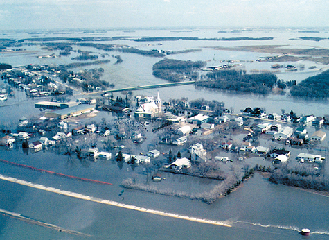
The dikes around East Grand Forks failed at 8:00 p.m. on Thursday, sirens sounding for an immediate evacuation of low-lying areas. By Friday afternoon, water in East Grand Forks came up to the roofs of some homes. Entire neighbourhoods were lost.
Rattled sandbaggers managed to save the University of North Dakota campus, but the dikes around downtown Grand Forks weren’t up to task, and floodwaters poured four feet deep through the streets in the early morning hours on Saturday. The power shorted out, historic buildings went up in flames, and a city was forever altered. Approximately 35,000 lost their homes.
But the Red’s most tantalizing prize was north of the border.
North of the Border
When news of the Grand Forks catastrophe reached Winnipeg, its citizens began to express concern. There remained a somewhat laissez-faire attitude among some, however. After all, Winnipeg had its famous floodway, and Grand Forks didn’t.
The floodway, a 60-foot trench that ran 47 kilometres from St. Norbert on Winnipeg’s south side to just north of Lockport, had saved the city in the earlier floods of 1979 of 1996. This massive water diversion had been built to handle approximately twice as much water as the river itself could carry.The floodway had been pushed into operation to some extent most years in recent memory, including 1969, 1970, 1971, 1972, 1974, 1975, 1976, 1978, 1979, 1982, 1983, 1986, 1987, 1989, 1992, 1995, and 1996. Many believed the floodway gates would lift again, and with the help of the city’s complex network of supplemental dikes, that would be the end of it.
Officials from all levels of government knew better by now that this flood would strain the province’s resources to the breaking point, and they had about a week and a half to prepare for the worst.
South of Winnipeg
Infantrymen from the Canadian Forces stationed in Manitoba set to work in the second week of April to fortify the towns of Ste. Agathe and St. Adolphe with sandbags. However, Major-General Bruce Jeffries, the commander of land forces in Western Canada, foresaw the need for additional aid, so he met with Brigadier-General Robert Meating, commander of the First Canadian Mechanized Brigade Group, and they ordered the Princess Patricia’s Canadian Light Infantry’s first battalion to redeploy from their home base in Calgary to Manitoba. The official name for the action was Operation Assistance.
Eight towns dotted the flood plain between the border and Winnipeg—Emerson, Letellier, Dominion City, St. Jean Baptiste, Morris, Rosenort, Ste. Agathe, Brunkild, and St. Adolphe—and just about all of them had full ring dikes. The region’s many farmhouses and rural properties had similar protections, either their own ring dikes or raised foundations built up to withstand most floods.
But this wouldn’t be like most floods.
Monday, April 21
Upon his arrival, Brig.-Gen. Meating toured the towns south of the city. When he stepped foot in St. Adolphe, he was disturbed by the relaxed, complacent demeanour of its residents. He witnessed people driving to work in the morning, going about business as usual.
Meating immediately began to argue in favour of a complete evacuation of the valley, both the towns and the rural areas. In doing so, he found himself in conflict with agriculture officials who advocated on behalf of rural residents who demanded that they be allowed to remain on their farms to save them from encroaching floodwaters. Meating’s priority was the potential loss of life, whereas agriculture officials concerned themselves with saving livelihoods. Even after the flood came and went, people would still need to make a living.
Mayors from the affected municipalities (MacDonald, Ritchot, Morris, De Salaberry, Montcalm, and Franklin) concurred about evacuating the towns. The logic was sound. In the event that any of the towns’ high ring dikes failed and water crashed in from above, residents would have nowhere to escape. However, the mayors believed the farms were a different situation and that they should be allowed to fend for themselves.
Wednesday, April 23
The evacuation got underway after the province’s Emergency Management Organization (EMO) ordered the towns cleared from Emerson to Winnipeg. Sirens began to sound at 5:00 a.m., and by Thursday night more than 17,000 people had left their homes, leaving behind a skeleton crew of floodfighters to patrol the dikes.
Tim Siferd and Kathleen Martin lived in St. Adolphe with their young family, and though floods were common along the Red, they had never experienced anything approaching this level of urgency.
Siferd and Martin remember well the anxiety they faced as the gravity of the flood situation increased from day to day. When the province finally issued the evacuation order, the couple moved all of their furniture and appliances to the second story of their home. The existing dike had already been raised by five to six feet and the groundcrews were getting ready to close off the highway at both ends of the community.
“They began the evacuations around Emerson and were putting [people] up in hotels in the south end of the city,” says Martin. “By the time they got to us, we were being billeted to hotels out by the airport.”
The couple left with their four children, the youngest only one year old. Their hotel room was sparsely furnished with a television and two double beds between six people. They were given daily meal vouchers for the hotel restaurant. By the first day, there was already a two-hour wait to get into the restaurant.
Within a short time, uprooted St. Adolphe residents began pooling their resources to make hotel living more comfortable. One teacher managed to find space within the hotel to organize a makeshift classroom where the children could continue their education.
Robert Stefaniuk held a weighty position during the flood. As mayor of Ritchot, his jurisdiction included both St. Adolphe and its imperilled neighbour to the south, Ste. Agathe.
“Young and old, strangers and friends came together,” says Stefaniuk. “It was not one event but the whole experience that left a lasting impression of the true meaning of community and the endurance of the human spirit.”
According to Stefaniuk, the evacuation took a particularly heavy toll on the patients and staff of the St. Adolphe nursing home, the stress of the sudden move compounded by both physical and cognitive barriers. Thankfully, the staff was able to move alongside the residents, easing their difficult transition, at least in part.
Stefaniuk and his family were evacuated like everyone else as the floodwaters approached. They were billeted at the Crowne Plaza.
The situation in Ste. Agathe was much the same, although it didn’t have a full ring dike like St. Adolphe did. Because of the community’s relatively high altitude, it hadn’t been deemed necessary to build a dike that surrounded the entire town. Instead, Ste. Agathe’s defences relied on a single dike along the banks of the Red that ran parallel to the town’s main street.
Jeannot Robert, a long-time resident of Ste. Agathe, took the lead in organizing hundreds of volunteers, assigning tasks and instructing people on how to build sandbag dikes. Both he and fellow resident Shaun Crew say they will never forget the incredible undertaking.
Despite its higher elevation and lower risk of flooding, Ste. Agathe was also evacuated save for a few who stayed to operate pumps, repair dike breaches, and watch and wait.
Thursday, April 24
Until the 1979 flood, Grande Pointe didn’t have rules regulating home elevation. Afterward, the government enacted legislation to ensure that all future homes in the area had foundations over 771 feet above sea level. Many new homebuilders went to significant expense to meet this requirement, spending approximately $1,000 per foot.
Back in the early days of April, immediately following the snowstorm, Stefaniuk had anticipated high water levels, so Ritchot’s council put in an order for 100,000 sandbags at a cost of $165,000. The supplier indicated that if the municipality needed more, the supply would be endless.
But it wasn’t. After the flooding of Grand Forks, people throughout the Red River Valley began stockpiling sandbags, and the suppliers all ran dry by April 21.
On Tuesday, April 22, nothing was amiss in Grande Pointe. Flash forward two days later, and residents were scrambling to deal with an unexpected deluge of water that seemed to come from all directions at once. On Wednesday, the water swelled substantially, rising five feet within just a few hours. For days prior, residents who feared the worst had been lining up outside the municipal office in St. Adolphe to request additional sandbags. The municipality didn’t have any left, and all they could do was add people’s names to an ever-growing list. Some even wondered if Grande Pointe would be evacuated, as it hadn’t been part of the earlier evacuation order. No one at the municipal office seemed to know.
Sand did eventually arrive on Friday, but the only way to get it to the affected properties was by boat, and most boats could only handle 15 or fewer bags at a time. The process was too slow to help many homeowners.
The evacuation order was further extended, and the RCMP went home to home throughout the day on Friday forcing people to leave.
The Brunkild Gap and the Z-Dike
Ron Richardson, a Highways Department hydrology engineer, spent some time looking at maps on Monday, April 21, in an effort to understand where the floodwaters would spread. As he studied the topography southwest of Winnipeg, he grew increasingly concerned. The last tributary entering the Red River south of Winnipeg was the La Salle River, and it entered the river behind the floodway gates, meaning that its waters wouldn’t get diverted into the floodway. This was part of the design, however, and no one thought it would be a problem—so long as the Red didn’t rise so high upstream that its waters spilled into the La Salle River basin and essentially did an end-run around Winnipeg’s protections.
The cause of Richardson’s concern? By his calculations, the Red River was primed to do exactly that.
“So I just called [Frank Barlishen, of Water Resources] and, basically, off the cuff, asked: ‘By the way, Frank, what keeps the water from breaking around to the north of Brunkild [at a point of low elevation] and dropping into the La Salle basin?”2
Barlishen had been under the impression that high ground between the rising Red and the La Salle basin would preclude this possibility. Indeed, a host of experts began to study the matter. Alarmingly, the threat was real. Not only that, but staff from Water Resources observed the next day that river water was already flowing backwards from the Red towards that very low point of elevation: the Brunkild Gap.
Winnipeg had a critical break in its defences.
If the city was to be saved, the series of dikes serving to divert water into the floodway channel would have to be extended. Within twenty-four hours, a group of surveyors completed a new elevation map which ordinarily should have taken at least two weeks. They identified the ideal route for the proposed dike extension: a 24-kilometre zigzag route heading west of the intersection of Highways 305 and 330. This became known as the Z-Dike, and the government rapidly approved its construction.
The only problem? They likely only had 72 hours to complete it.
Equipment was procured from everywhere it could be found. Other difficulties involved securing (and transporting) the necessary material for the dike, and the struggles inherent with digging up frozen ground. And with government, private enterprise, and the army all working in close quarters, they would have to find a way to effectively coordinate their efforts.
“I really think that a good number of people felt we will give it the Boy Scout try, but it is an impossible task,” said Walter Saltzberg, the Highways Department’s director of bridges and structures. “We were going to try it and we were going to put our best foot forward and do our best. But…”3
By Friday, April 25, hundreds of pieces of equipment were frantically at work. In order to allow the operators to work through the nights, Griffin helicopters were pressed into service, hovering above the worksites with two-million-candlepower flares.
Without a doubt, if the Z-Dike wasn’t completed in time, if Winnipeg wasn’t saved, it would end up being among the most profound natural disasters in North American history.
Sunday, April 27
With the flood forecast swelling beyond all early projections, another community that had thought itself safe received a harsh awakening.
“[On] a Sunday afternoon in late April,” Mayor Braun of Niverville relates, “I received a call from [town administrator] Jim Buys indicating that we had been directed by Manitoba Water and Conservation Stewardship to build a dike on the north and west side of Niverville. The message we received was that this flood would match the one of 1950 and we could expect water at the railway tracks on the west side of town within three days.”
The news circulated quickly, and Braun recalls that it was met with suspicion and cynicism in the town’s coffee shops. The ridiculousness of a flood of that magnitude repeating itself was more than some were willing to bargain on. The notion of a dike being built around a community six kilometres from the river was met with mockery.
An emergency meeting was called on the same night and questions began to arise. Who would pay for the half-million-dollar temporary dike? How would they find construction crews with large equipment on such short notice when most were already busy working at the Z-Dike? Would the town need permission from landowners whose land the dike would run along? Much of this land belonged to Ritchot, the neighbouring municipality. Land which Niverville had no jurisdiction over.
Fortunately, the urgency of the situation meant that municipalities were working together better than ever.
“The challenge was to get the many different levels of government and organizations to work together in a fashion that maximized all our resources,” says Ritchot mayor Robert Stefaniuk. “Since it was the largest flood seen by any living soul, we needed to maximize and utilize everything and everyone.”
Understanding the enormity of the situation, Ritchot gave its approval for Niverville’s dike to cross their boundaries, and Chris Wiebe of Wiebe Investments came to the rescue with large equipment of his own, as well as some that was secured from a friend in Dugald.
“Within four hours [of that Sunday meeting], the earth-moving equipment was on the fields,” Braun says. “The construction that began that night would go 24/7, through the night, to ensure that the flood protection was in place by Wednesday morning. The problem for the construction crews lay in that the large accumulation of snow first had to be moved out. Then they had to rake off the frozen topsoil and get it out of the way in order to get at the clay which was needed to build the dike. The construction to build higher went on while the water was rising on the west and north side.”
At the same time that Niverville was hastily erecting its temporary dike, the flood was cresting in Emerson and beginning its inexorable march into Manitoba. Officials there were relieved to discover that the water was two and a half feet lower than expected. But it was still higher than any other flood in living memory.
The good news: Emerson’s dikes, built four and a half feet higher than the crest, held strong. The bad news: 60-kilometre-per-hour winds were whipping water against many out-of-town property dikes. Although high enough, many of them failed under the onslaught. Losses throughout the valley were proving to be staggeringly high.
Finally, the EMO chose to overrule the municipalities’ objections to extending the evacuation order to those living on rural farms. A provincial emergency declaration gave them the power to do this despite the fact that the municipal mayors and councils refused to sign the order.
Although the RCMP officially made no arrests, they began showing up at residents’ doors with soldiers and handcuffs. They didn’t give these homeowners a choice but to come with them.
Gene Whitney, who served as councillor for the Ste. Agathe ward of Ritchot until he retired from civic government in 2002, says that there was tension between the municipality and the military when it came to the evacuation order.
Whitney says that he attended a meeting at which the military decided to go from house to house in pairs, one representative from the RCMP and one representative from the military, and tell people to get out.
“I told [the officer at the meeting], ‘You don’t need to bother the people in my ward that I’m responsible for, because I already talked to these people,’” says Whitney. “Anyway, the next morning I get a call from Alex Fast, and [the military] has been around to tell him to get the hell out, and his brother, and Jakey Dyck… So I got a hold of the [officer] and I said, ‘Those three people that you harassed, they all fish, they all know how to boat, they’re farmers, they’re innovative, the whole bit.’ They knew how to look after themselves.”
According to Whitney, he had to intervene to help residents get through the militray checkpoint near Niverville so they could return to their properties. “I had to go to the checkpoint, because [the military] was holding them up. I had to tell the sergeant, ‘Just leave them alone. They’re not going to be a problem.’”
The situation proved so controversial that the EMO eventually gave up and stopped enforcing the order. But not until a lot of people were taken away and prevented from trying to save their properties.
In hindsight, Whitney adds that the military took their experience during the flood and made the most of it the following year, when they responded to the ice storm disaster in eastern Ontario in Quebec. “They did a bang-up job there,” Whitney says, “because they found out, as I and many others told them, ‘Listen to the local people. They know the lay of the land.’”
But in Manitoba, the situation was about to deteriorate further: a spring storm was forecast to hit the region late on Monday.
Monday, April 28
Fortune shone on the Z-Dike builders, buying them four additional days. As the flood expanded west, the network of roads and natural rises between the river and the dike slowed the encroaching waters long enough for the operators to complete their work. The howling north winds also played a role in holding back the water. Upon completion, an oil boom was dropped in front of the dike to assist in breaking up the wave action.
But the Z-Dike brought with it some unintended consequences. Although it would protect Winnipeg, it didn’t work in Ste. Agathe’s favour. Rushing waters from the south crashed up against the Z-Dike Monday night and diverted eastward. Ste. Agathe lay helplessly in its path.
“I remember standing on [Highway 75] at approximately 8:00 p.m. and looking southwest,” says Jeannot Robert. “I noticed the elevation on the waters coming towards Ste. Agathe across the fields. It was then that I felt a sense of hopelessness for all our efforts and hard work. At midnight, workers informed me that the water was coming over the tracks and quickly over Highway 75, across our village. I remember asking a fellow worker, just before we inundated, to make sure the large diesel pump on the south side of town was full of diesel. He came back and said, ‘Mr. Robert, I can’t find the pump.’ It was under two feet of water. Everybody laughed and we knew we were done.”
The water had rushed in over the unprotected west side of town, rapidly filling the community and most of its homes and businesses. Moving quickly, crews opened up the dike on the east side to allow the trapped water to gain access to the Red River.
“There was a feeling of despair as a few dozen of us watched,” says Robert. “All we could do was to pick up the equipment quickly and store it. We left town via [Highway] 305 eastward as water was coming over. I remember thinking, ‘How high is this going to get?’ We had formed a caravan and made it to Highway 59, pushing water at places.”
According to Robert, some areas of Ste. Agathe saw up to five feet of water. The hotel and many homes were badly damaged. Portions of the school later needed to be demolished and rebuilt. The waves were two to three feet high, with whitecaps. 500 homes were destroyed.
“I was standing on the dike in front of my house on Main Street,” says Gene Whitney, Ritchot councillor. “You have to have a perverse sense of humour, I think. The guy who owned the hotel, he tried to leave and get to Highway 75, but the water was coming over it. It was between three and four feet high there. This guy went up to the intersection of Cheyenne Street, right beside the hotel, and he knew he couldn’t go any farther. He was running down the street carrying two suitcases and the water was about four feet behind him. I stood on the dike and watched the water come up against it and start to run into my basement.”
But at least the Z-Dike held.
At the Crowne Plaza, Stefaniuk received a call at 6:30 a.m. from Harold Clayton at the EMO, informing him about what had happened in Ste. Agathe.
“I was shocked,” Stefaniuk later told a Free Press reporter. “I couldn’t believe it. It was a very bad day.”4
But Stefaniuk is quick to point out that the province was both helpful and supportive during this time. In his mind, the province made the sensible decision in building the Z-Dike to protect Winnipeg, the economic centre of the province.
“My greatest challenge during that time was keeping on top of the questions and concerns of the residents,” says Stefaniuk. “I made sure we answered every call and attended every meeting. The challenge lay not so much in the volume [of calls], but in the emotional aspect. It was an emotional time for everyone, including myself. My heart broke for them. It wasn’t just houses we were fighting for, it was peoples’ homes. Those are two completely different things.”
Shaun Crew was one of those people fighting for his home. With a property situated on the riverbank outside Ste. Agathe’s dike, he had organized a crew to sandbag alongside him. He describes the emotions of shock and disbelief upon discovering that his hometown was inundated by water.
“I had no idea whether or not my own home ring dike would have held and whether or not pumps I had set up to handle the worst would even be running,” says Crew, who had been evacuated just before the flood arrived. “I was able to enter Ste. Agathe the following morning by launching a boat off of the Z-Dike… across the fields and Highway 75 to my front door. My own dike had held and I suffered no damage to my home. Property damage was a whole other matter.”
Tuesday, April 29
As the weather worsened, the flood arrived in Niverville a little bit earlier than projected. A taskforce was immediately put into place. Niverville school teacher Harry McKnight was instrumental in his role as emergency coordinator. The town’s firefighters assumed around-the-clock responsibility for patrolling the dike for breaches.
“There were some close calls on the northwest corner of town as the water was about five feet high on the dike at places,” recalls Braun. “When the north wind blew, the hastily built dike faced incredible pressure, but it held.”
The Word of Life Church and Niverville Collegiate Institute quickly became home base for the military. Positioned on the edge of the flood, Niverville was a perfect staging ground for their continued operations in the region. They set up equipment in parking lots, cots in the gymnasium, and a mess hall in the church.
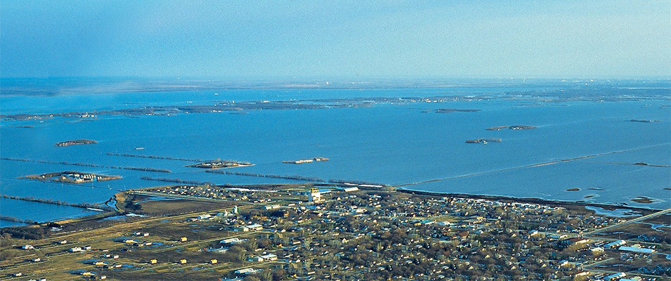
“I seem to recall the buzz that went through certain segments of the community when the military arrived,” says Braun. “Friendships were formed amongst some community members and the soldiers. I recall greeting the commanding officer of the Canadian military on the land now occupied by the Vista Cove condos. His helicopter landing drew a huge crowd. I recall the opportunity provided to municipal leaders to take an airplane tour of the Red River Valley. It was unbelievable to see it all from the air.”
“Looking back now, it all seems a bit surreal,” Stefaniuk adds. “I vividly recall flying over the area. Once we passed the floodway, we came upon what was to become known as the Red Sea. We could not see the water’s edge. What was [once a] sprawling prairie was gone. It was a staggering amount of water and to see it from that perspective was shocking. The strength and power of Mother Nature was truly awe-inspiring and was only [mitigated], I found, by the strength and power of the human spirit.”
Fortunately, all the other towns’ ring dikes held. Hundreds of buildings throughout the valley, however—mostly farmhouses but also a church, a school, and a seniors home—weren’t so lucky.
Braun applauds the enormous support that poured in from the entire community, including a group of local women who prepared food in the Son City building day in and day out, feeding the soldiers and local volunteers. Those who had earlier been sceptical about the possibility of such a massive event now looked on as their community rallied hard against the odds.
Just as persistent wind and waves tested the Z-Dike, the floodwaters began to recede in Emerson.
The end may have been in sight, but for some residents of the southeast the worst was still to come.
Friday, May 2
The crisis in Grande Pointe roared into town swiftly.
When the crest finally arrived in Winnipeg, the river within the city was at its maximum allowable level, 24.5 feet above the riverbed at the James Avenue pumping station. If the city let any more water through the floodway gates, the network of dikes throughout the city would almost certainly undergo systemic failure. At the same time, the floodway was already at its maximum designed capacity, 60,000 cubic feet per second.
Faced with no other option, the floodway gates rose even further, pushing the floodway to an untested 64,000 cubic feet per second. As long as the floodway didn’t fail, this move would save the city.
But there was a cost. Just as Ste. Agathe had arguably borne the brunt of redirected water from the Z-Dike, raising the floodway gates beyond capacity would force a torrent of water to flow backwards—south, straight into the 150 homes in Grande Pointe, many of which were barely hanging on after the sudden overland flooding that had occurred on April 23. However, the Department of Natural Resources calculated that the water level in Grande Pointe would go up a mere six inches. And that was that.
This was only the latest in a series of failed flood predictions. Instead of rising six inches, the floodwaters surged up several feet. This wasn’t the straw that broke the camel’s back so much as the two-by-four.
“I don’t think the officials exactly knew what was going on,” said Grande Pointe resident Elmer Hywarren to the Free Press. “They’ve bungled it here as they did in Ste. Agathe. They had their computer models and obviously their computer models were not right.”5
Another resident, Claude Lemoine, agreed. He was quoted in the same article, saying, “We’re paying the price of protecting the city. They’ve given up on us. They’re using us as their catch basin.”6
Tim Siferd, having evacuated with his family a week and a half earlier from St. Adolphe, had spent the intervening time with his colleagues at Fisheries and Oceans Canada. On a variety of watercraft, they had been kept busy bringing aid to areas south of Winnipeg.
“We did a lot of sandbagging before the flood hit. After the flood, we were going around with a bunch of boats because we worked for Fisheries and Oceans,” says Siferd. “We used them to do a lot of sandbagging and try and save the people in Grande Pointe. When Grande Pointe was going down, we were transporting army personnel back and forth… To me it was a lot of fun because it got me out of the office.”
Typically, the crew would go out in two boats, with two people per boat. There was a constant threat of submerged signs, trees, vehicles, and debris which could cause damage to boats or endanger their lives. Siferd recalls flagging the tops of submerged road signs for other boaters.
Throughout the day, one family after another lost their battle with rising water, even in cases where the foundations had been built up to the government’s own specifications.
And the situation only got worse, with the floodway gates being raised again on Saturday, and yet again on Sunday. At the height of the disaster, the floodway was accommodating 65,100 cubic feet of water per second. (For sake of comparison, remember that the Red River’s typical discharge is only 8,334 cubic feet per second.)
Of Grande Pointe’s 150 homes, a mere 25 survived.
The flood forecasters seemed to be at a loss to explain it. Larry Whitney, speaking on behalf of the EMO, insisted again that raising the floodway gates beyond capacity could only have brought the water level up by six inches in Grande Pointe. He blamed the extra water on “unpredictable flow patterns.”
So, was it true that Grande Pointe had been knowingly surrendered to the waters? In a game of chess, was Winnipeg the queen and Grande Pointe an expendable pawn?
An employee from Water Resources later suggested that the sudden rise in water in Grande Pointe might be blamed on the CP Rail track near Niverville becoming submerged, which had never happened before. The implication was that water had gotten up onto the railbed, and then channelled north into Grande Pointe along the raised stretch of track.
This explanation went over about as well as you might expect.
Receding Waters
The battle over compensation dragged on for months after the flood receded. Life may have returned to normal in Winnipeg, but not in communities like Ste. Agathe and Grande Pointe, and not for the hundreds of people who lived in farms peppered throughout the countryside. These Manitobans struggled to move on, especially when it was revealed that the maximum flood compensation would be $80,000, far short of the expenses most homeowners were facing.
Matters only got more acrimonious when Premier Gary Filmon publicly stated that people who chose to live on a flood plain had to be prepared to accept some of the risk. This was compounded by another statement Filmon made on July 27: “In some cases, people chose to live outside the city for lifestyle to avoid higher taxes and they pay no premiums and now they are having a lot of money paid to them by the taxpayer at large.”7
Some residents in the southeast are still bitter about that, even though the government did eventually raise the compensation levels.
“The problem with the flood that year was that we never got a [final] forecast,” says Siferd. “It kept going up and up. And then… Gary Filmon absconded with all of the heavy equipment to build the Z-Dike to protect the city. And then he goes on TV and says that people have to take responsibility for where they live. I’ve never forgiven him for that to this day.”
Furthermore, the compensation trickled out at a glacial pace, the frantic rapidity of government decisions at the height of the flood giving way to more typical bureaucracy. Residents felt helpless, confused, and frustrated. Some legitimately wondered if help would come in time for them to get settled for the coming winter.
In the years to follow, homes were rebuilt and communities adjusted to a new reality. Sandbags were removed, debris hauled out, destroyed structures demolished.
The municipalities have undergone extensive flood-proofing to protect against future floods of that scale. The City of Winnipeg spent a not-insignificant fortune to expand the floodway. Ste. Agathe received a permanent ring dike within a couple of years, two feet above the 1997 flood level. Niverville, too, erected a permanent dike. The Z-Dike has been upgraded and extended into an impenetrable earthen wall. Meanwhile, a study is underway to examine the prospects of raising all dikes in the valley to a 200-year-level event.
Gene Whitney, who was the Public Works Chairman for Ritchot, says that when the province redirected Highway 75 around Grande Pointe, they raised the northbound lanes considerably to act as a natural dike. And on the other side of the community, they closed some roads in order to accommodate bigger, better ditches to handle overflow.
Both Jeannot Robert and Shaun Crew of Ste. Agathe agree that their community is one of outstanding resilience and goodwill.
“The people of Ste. Agathe are unbelievable,” says Robert, noting that he believes the community is now well protected. “You didn’t have to ask for help; they were there, side by side, [working] for a common goal. When the waters left, they were there again for the cleanup and re-entry. It seems that they all got on a high and did not quit after the flood but continued to improve [and] rebuild.”
Two decades later, Ste. Agathe has grown considerably. Before the flood, the community had about 100 homes. Now there are 260 homes, a commercial park, and new amenities and businesses. Niverville’s population has tripled. St. Adolphe has doubled in size, and Grande Pointe is also bursting at the seams.
The memories of 1997 will never fade, and with every new spring, residents along the Red River must live with the apprehension of what may come. Flood forecasts have improved markedly. The topography of the valley is more thoroughly mapped, computers are able to predict water flow with far greater precision, and the infrastructure of our communities is stronger than ever.
But ultimately it’s not the strength of our dikes that defines us; it’s the strength of our people.