

With summer finally on our doorstep, the announcement of new greenspace funding is indeed a timely one. Thanks to the Building Sustainable Communities grant, an initiative of the provincial government, an approximate $55,000 in funding will be allocated toward two Niverville parks: Opa’s Park and the brand-new Niverville CPR Well Historical Park.
Opa’s Park
The Opa’s Park Restoration Project was the brainchild of Niverville resident Beth Downey in 2021. The park, which borders Roselawn Bay and Edelweiss Crescent, imbues fond childhood memories for Downey.
Now, as the mother of a toddler, she wants the park to inspire her young son and other children of the community in the same way.
The park has a long-standing history in the community. The land was originally donated to the town by William and Anna Dyck, founders of Wm. Dyck & Sons of Niverville, and, at their request, was to be permanently designated as park space for the enjoyment of families for years to come.
“We are elated to learn that Niverville has received this provincial grant for crucial greenspace investments, and all the more so knowing Opa’s Park will benefit,” says Downey.
Restoration of the park, she adds, will be implemented in three phases. The first phase, scheduled for this summer, will include a major planting of the grounds to incorporate a native prairie garden as well as a sensory pollinator garden where families can explore and learn about the earth’s native flora.
A series of walking trails and a natural timber obstacle course will provide further activity for the young ones, and, if funds allow, boards will be erected around the perimeter of the existing basketball court to extend its usefulness into the winter months as an ice rink.
Since funding for phase one was already in place thanks to the generosity of local business owners and private individuals, Downey says the new funds will bolster plans for phase two. That phase will include wheelchair-accessible play features, botanical gardens with wildlife host infrastructure, and educational signage throughout the gardens.
CPR Well Historical Park
The planned CPR Well Historical Park is aptly named for its unique attributes: its location immediately bordering the CPR railway tracks, and the fact that a well of significant historical relevance lies here, just beneath the earth’s surface.
Funds from the grant will be used for the creation of a community pocket park which will draw attention to and commemorate one of the few remnants of Niverville’s coloured history as a railway community.
Ernie Braun, a local history enthusiast, is in part behind the initiative to tell the old well’s story through visuals and educational reader boards. Working together with Shirley Hoult of Communities in Bloom, the duo can now push their plans from concept to reality.
“Niverville is one of the oldest urban service centres on the East Reserve,” Braun says. “But almost all the historical markers—like the elevator, the station houses, the various hotels, and now even the old Main Street store—are all gone.”
The discovery of the old well dates back to 2012 when a tractor operated by a town employee tipped precariously into a newly developed sinkhole on the west side of the tracks. When it was pulled from the cavity, the still-intact brick walls of a well from a bygone era were revealed.
Well over a century ago, during the epoch of the steam locomotive, Niverville was chosen as the first “tank station” for trains running along the Pembina Branch of the CPR between St. Boniface and St. Paul, Minnesota. Since the trains were steam-driven, water tank locations acted as fuelling stations for the trains as they made their journey.
A filling tank, which sat trackside somewhere near the well, was constructed between 1880 and 1881 and served its objective until the CPR phased out the steam locomotive around the middle of the twentieth century. After that, the tank was removed and the well closed and covered.
Upon its rediscovery in 2012, Bernie Falk, a town employee at the time, took some photos of the subterranean relic and showed them to Braun. By the time Braun had a chance to make inquiries with the town, the hole had been filled and new grass planted over it.
In July 2020, Braun and Falk set out to relocate the old well site using historical imagery from Google Earth. They created a grid and began pushing steel rods into the ground systematically, hoping to hit a wall of the old well. They succeeded in their quest, paced out the nine-foot stone perimeter, and marked the location with a peg.
As major development plans began to take shape for the business section west of the tracks, Braun envisioned images of the well site being permanently lost to upcoming infrastructure. He found a receptive ear as he approached town council with a concept to preserve the space and commemorate the history before it was too late.
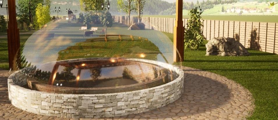
From there, Braun initiated the help of Winnipeg architect Harold Funk for ideas to create a park draft. Digital designer and personal friend of Braun’s, Brent Wiebe, created an artist’s rendering of what the park could look like.
“The well site is a perfect place to create walking spaces, greenspace, and a commemorative site,” Braun says. “This site will interest the community for recreational reasons, but it will also interest the wider tourist population who will be passing through Niverville now that we have the great CRRC for year-round activity. It will be an opportunity to showcase our history, and to showcase the value that this community places on its history, in the same way that the Métis Red River Cart, the Heritage Wall, the replica elevator, the plaques along Main Street, and the cultural space in the rec centre do.”
While it’s too early to speak with certainty, Braun imagines the initial grant funding to be directed at excavating the well and restoring it as best as possible. He hopes for a timber-frame shelter to cover it and possibly a plexiglass dome over the well opening to prevent falling risks and to protect the integrity of the well from the elements.
The plan provides for landscaping with native trees, shrubbery and grasses, walking paths, benches and picnic tables. And, of course, plaques along the path to bring the well’s rich history back to life.